 This is a longer post so settle in. Day five, or day one of the backpacking portion of The Big Ditch if you rather.
Approx. 11km with 1445m of elevation loss.
A windy & cold start to the day, caught the shuttle from the backcountry office to the Trailhead where the 'light & fast' crowd quickly dispersed for their day of likely down the river & back in a day.  It was just getting light as we got on the trail so we got to enjoy the sunrise as we made our way down the first set of switchbacks.


 Typical trail construction beaten by many boots & hooves. We got lucky as part of the South Kaibab trail was under construction so all Mule traffic was routed to Bright Angel trail. Lucky in the respect of less dust from the Mule trains & no fresh manure on the trail. This is the most direct route to the river but has no water sources so it is best suited to a descent route. Also since you are facing out you get to take in the views as the other South approach trail (Bright Angel, which we used on the way out) is partially in canyons without the long views.

 These exposed sections were fun with the gusts of wind buffetting us. Big packs don't hold you down, they act like sails!
 Moe taking in the views. Despite his efforts his pack was a little disheveled the first little ways. Misfiled sunglasses & a mutinous sandal made from some light entertainment at his expense.


 Amazing trail construction. Much of it built by the CCC (Civilian Conservation Corps) which was an employment effort undertaken from 1933-1942. They built trails among other things all over the U.S. Hats off to those guys, mostly all gone now.
 Now things are getting toasty with the full sun & subsiding wind. It is truly the opposite of climbing a mountain where you might carry a jacket only for the summit.


 If I'm not mistaken this is called 'The Tip Off'.
 That patch of green is Bright Angel Campground, a little further up is Phantom Ranch.
 Colorado River & the Silver Bridge.

 The Black Bridge & Boat Beach.
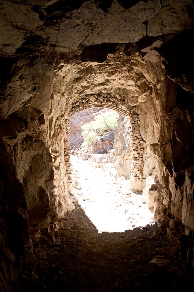
 Tunnel out onto the Black Bridge.
 The Black Bridge. Built in 1928 it is 440' (134m) across. The most amazing thing about its construction is each of the 1.5" diameter steel cables weighing more than one ton each were carried to the bottom by Havasupai Indian labourers via the South Kaibab trail. How they did this I don't know but my backpack felt a little lighter thinking of that feat.
  This is the bridge the Mules must cross as it has a plank deck & they can't look down thru it.
 Some rafts & kayaks at Boat Beach. Almost there!
 Shady Bright Angel Campground. While it was not a long day it was long enough.
 We set up camp without bothering with the tent fly... it was dry & hot. Calves were very tight, not normal for a day of mostly descent but due to the sleepers across the trail & depressions made by the mules each step down was absorbed first by the toe & then the quad so the calves took an unexpected beating. Now it's getting really hot...
Monday, November 30, 2009
South Kaibab to Bright Angel CG
Mather Point - Sunset
 After touring the South Rim we set up camp at Mather campground & proceeded to pack for our four nights below the rim. I was either more prepared or just quicker than Moe who conceeded that he needed the time to prepare & bade me good luck with the sunset tour. Burning daylight I left him to curse his gear in private & off I went to find it was already getting late for a good spot.
 I was aware that I should arrive early & sure enough tripod toting photographers were already in place at all the choice perches but I made out ok by sharpening my elbows a bit. Stupid in such a wide open place to stand like you're in the queue for a football game urinal but it was worth it for the show.
 The sky, the changing colors of the stone, & creeping shadows were ever changing.
 I stayed until dark (thinking ahead for a change, I had crammed my headlamp in my pocket at the last minute) & headed back to find Moe at peace with his packing job more or less ready for the big day tomorrow. As was the pattern it was another dinner by headlamp... carb up!
Grandview Point
 We stopped at quite a few of the viewpoints along the south rim but at Grandview we opted to go a little further & follow the trail down below the rim a short way.
 Of course you could backpack down this trail & connect with the Tonto trail, but that is for another trip. It was hard to turn around though... the trail just kept egging me onward.
 One of many interactions with the local population of touron here. In this one I stopped a man from throwing a fist sized rock off the trails edge (he was trying to get his friends to collect one too, to throw for 'Good luck' when I intervened) "There's a trail down there, you're going to kill someone!" He thanked me & apologized, clearly he hadn't been thinking... Thankfully most of my other encounters were more positive.
Desert View & Watchtower
 Desert View is the furthest east viewpoint along the south rim & provides views all the way down to the Colorado River. It is also the highest point on the south rim at 2267m.
 Looking up inside the Watchtower. Officially opened in 1933 it houses a ... wait for it... gift shop! (no way, really??) but its worth running yet another gauntlet for view out of the tower and of the murals on the walls.


 Looking down thru the center of the tower.
 The Desert View Watchtower was designed to mimic an Anasazi watchtower, only much bigger obviously. Too bad the very top is off limits to the public. Next time I gotta get me one of those green jackets...

 One of my favorite shots from the trip. I think its the cloud.

 Could have stayed here longer but there is much more to see...
